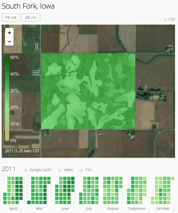
Know your field's water content

High resolution nowcasts of water content in soil based on a handful of sensors, or even no sensors at all.
Coverage anywhere in the continental United States.

Join the Beta

How It Works

Nowcasts of soil water content leverage a fusion of extensive historical and real-time data, fed through a series of rigorously tested models.

 Soil Texture

Proportions of sand, silt, and clay determine porosity and drying rate

 Topography

We model drainage paths across a given field, determining where water content will accumulate

 Hydroclimate

Seasonal climatic patterns, aridity, and runoff sources impact evaporation

 Precipitation

Recent rainfall drives current water content levels in soil

Two Ways to Access

 Visual Explorer

View our water content estimates directly from your browser, exploring the complete history of your fields.

Want to see more? Check out the demo, showing Soil Insight working with varied climates, soil textures, and topographies.

Check out our demo

 REST API

Integrate our water content estimates into your own analytics systems or into standalone applications like Microsoft Excel. Calls to the REST API take the form of HTTP GET requests:

api.soilinsight.com/api_key/site_name/latest

By default, responses are returned as CSV:

timestamp, lat, lon, vwc
2016-06-02T11:00Z, 42.4326, -93.5880, .238
2016-06-03T11:00Z, 42.5418, -93.3911, .382
2016-06-04T11:00Z, 42.6375, -93.2215, .383
CSV

The API can also return JSON, video (.mp4), and Google Earth (.kmz)

Leadership

Evan Coopersmith, PhD

Evan is an expert in soil water content modeling, who has worked with NASA, CDC, NOAA, and the USDA's Hydrology and Remote Sensing Laboratory. He holds a Ph.D. in Civil and Environmental Engineering from the University of Illinois and a B.S. in Operations Research and Financial Engineering from Princeton.

He has produced numerous publications applying machine learning algorithms to soil water content estimation, comparing sensor technologies, quantifying instrument error, validating satellite-based remote sensing, and describing American hydroclimatology. Previously, his algorithms traded profitably during the 2008-2009 financial meltdown, while he served as co-founder of a hedge fund at the New York Mercantile Exchange.

Andrew Collier

Andrew holds an M.S. in Civil Engineering from the University of Illinois and a B.S. in the same field from Notre Dame, and has served as an expert consultant, developing full stack web apps. His expertise lies in deploying software at scale, and he has experience in such varied topics as land use planning, transportation visualization, and environmental compliance. Over the past five years, he has been deployed to Hong Kong, Dublin, Singapore, Shanghai, and other locations for this purpose.